5th Feb: Navlink and kettle tests!
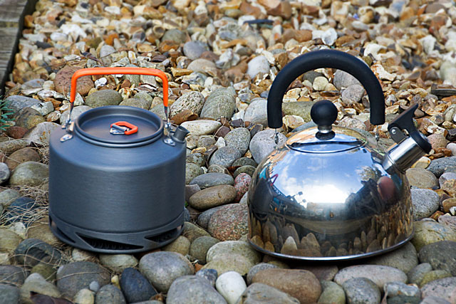
 The kettle I’ve been using on Seatern is a 1.5 litre stainless steel whistling kettle (on right in photo). It is quite large to store and, when used on the spirit stove, it doesn’t whistle! I decided to try one of the new sort of kettles with “heat transfer technology” (!) – basically an annular false bottom which is connected to the main kettle with heat exchange fins. I bought one from Angling Direct (much cheaper than Cotswold!) and, out of curiosity, compared the boiling times. For each kettle I used a new gas cartridge and started with the stove and the 0.5l water at room temperature (16C). The whistling kettle (base diameter 18.5 cm, weight 417g) took 3 min 45 sec. The new kettle (15cm, 303g) took 3 min 15 sec. So the new kettle is faster than the old one and easier to store. I also tried the 0.5 litre kettle from my trusty Trangia spirit stove which I used for camping (12cm, 143g). It took 3 min 50 sec, not much longer than the stainless kettle – however it was at the limit of what it could hold.
NavLink: Another success was the discovery that the Digital yacht “Navlink” application will run on my laptop and obtain GPS and AIS data simply by plugging a lead into the USB socket from the AIS transponder. NavLink cost £26 which includes a year’s access to UKHO charts. So I now have a second chart plotter and AIS display which is entirely independent of the Garmin Echomap apart from the need for a 12V supply (for the AIS transponder). I’ve also installed the NavLinkUK application on my iPhone (another £22 !) so that gives me a small GPS enabled chart plotter independent of the 12V supply (although using the GPS will run the iPhone battery down quite quickly). The two systems were very easy to set up and they also have the advantage of using automatically updated Admiralty Charts. I realise I could get the latter “free” from “Homeport” but the NavLink system was much easier to implement.
On the iPhone you can use the camera to view a scene and Navlink will superimpose chart details such as the bearing and identity of navigational marks. Whether the iPhone display is bright enough to be useful remains to be seen! NavLink does handles the AIS data much better than the Garmin which more often or not does not show the ship’s identity. NavLink actually plots the size of the ship on the chart and can give a description and photo of the vessel. Knowing whether a target is a ship or motorboat is good for knowing whether I have right of way! I tried to transmit AIS data to the iPhone by Bluetooth from the laptop but didn’t succeed. However in the process I found I could play music from my laptop via the JVC radio using Bluetooth – which is one wire less to fall over! Presently I’m reading the “Inshore along the Dorset Coast” book and the chart on the iPhone is convenient to follow. Music playing, daybed cruising!