
22nd March: Winds at Stone Point
This post is based on a post I have just published on the NCI Calshot “Blog” which was, in turn, based on a report to NCI aimed at getting a warning or disclaimer displayed next to published met data on the NCI’s web site. NCI and NCI stations appear to be an “official” data source and as such the met data might be given undue credence by someone venturing onto the water. In fact, getting a representative wind reading from a coastal site depends very much on the exposure of the anemometer for the existing wind direction. When NCI first started putting met data on the official website I questioned whether it was a good idea, but got no response, they just went ahead. Anyway, here is a version of what I wrote on the Blog:
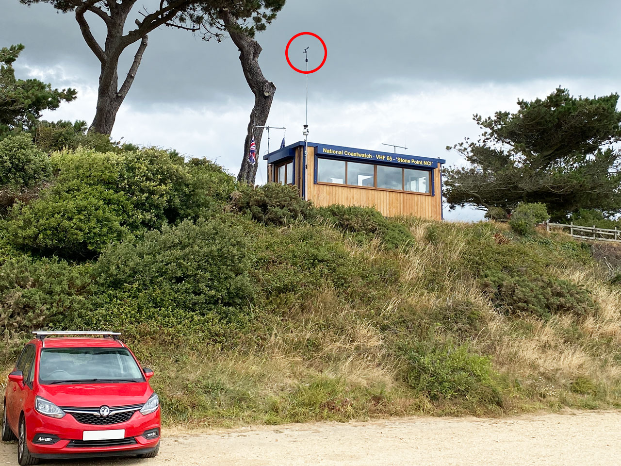
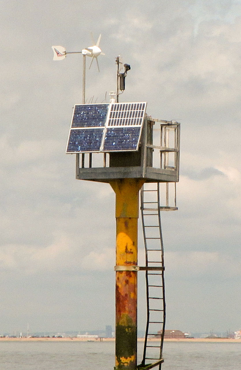
The photo shows the anemometer position at NCI Stone Point. It is probably better exposed than at many NCI stations, there is a tendency to mount the anemometer too close to the station roof. However we do have a lot of trees and bushes particularly to the east of the station.
So how well do the NCI Stone Point anemometer readings represent the wind over the nearby Solent waters?
During the period 24th February to 4th March 2024 the Solent experienced a series of small depressions which gave a wide range of wind speeds and directions, suitable for checking the anemometer values. I used past wind data from Stone Point from Davis Weatherlink at 15 minute intervals and compared the individual wind observations with those from the Bramble Met Post which, being surrounded by water, should indicate the actual wind strength over the central Solent.
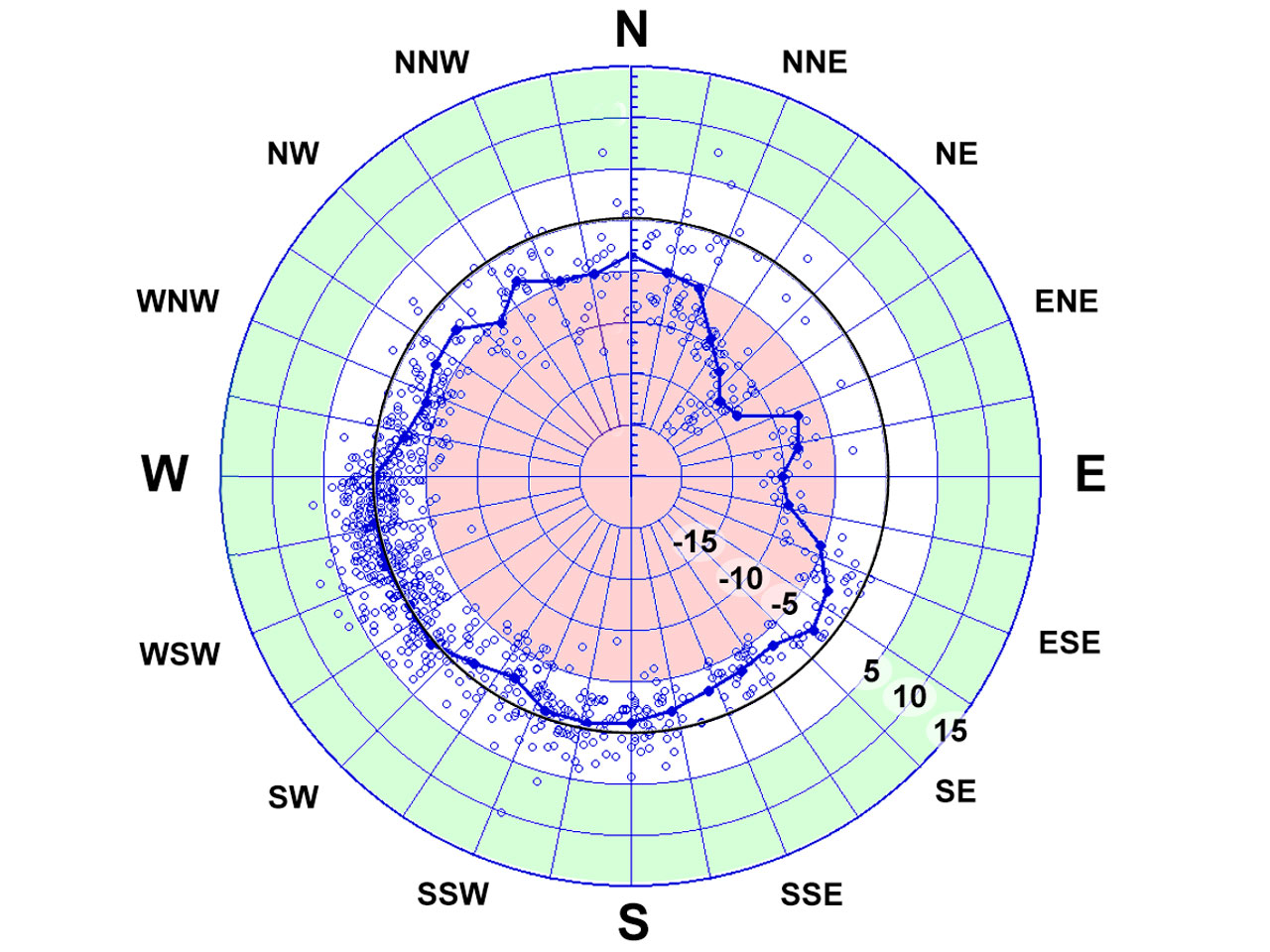 The plot shows the wind speed difference (Stone Point – Bramble) in knots plotted against the wind direction as measured at Bramble. The blue line shows the average difference for 10 degree intervals.
Ideally, the points should all lie on the circle of zero difference within the white area, which indicates there was agreement to within ± 5 kts. In the red area the Stone Point winds are less than those measured at Bramble Met Post by more than 5 kts, in the green area they are more than 5 kts greater.
Some of these individual differences will be due to the wind at Bramble being different to the wind at Lepe. However the average differences are probably due the Stone Point winds under-estimating the wind over the water. The plot suggests, for example, that on average Stone Point agrees with Bramble for winds from the SW but under-estimates the winds experienced at Bramble by 15 kts or more if the wind is from the NE, that is blowing from the land to the sea at Lepe.
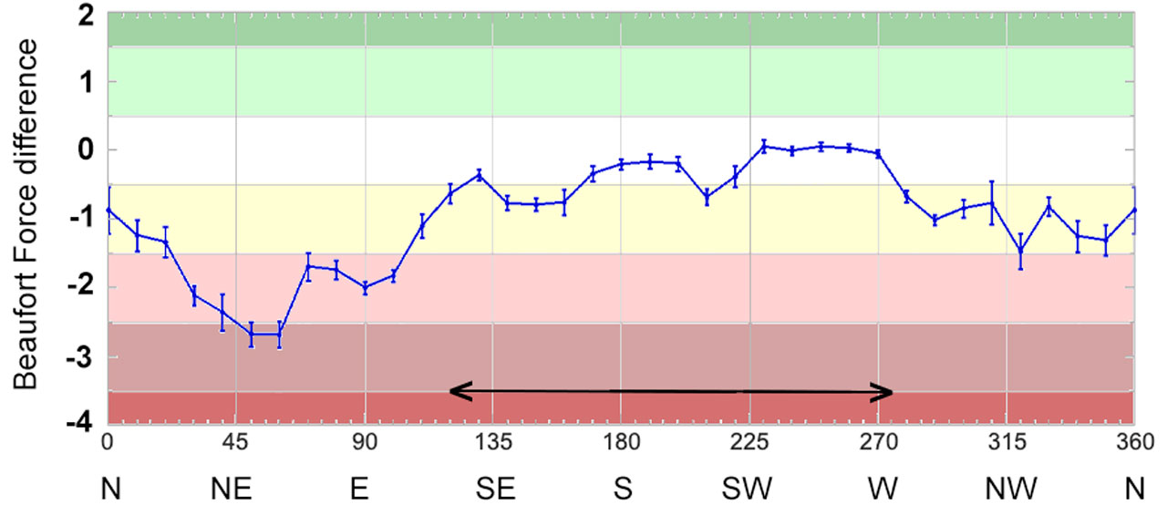 NCI stations report the wind strength as a Beaufort Force (BF) value. The next plot shows the average difference in BF estimates between Stone Point and Bramble. The white area indicates agreement, the yellow area indicates Stone Point winds were less by one BF value. The pink areas indicate Stone Point under-estimating the wind over the Solent by two or three BF values.
The wind directions for which the BF value recorded at Stone Point was generally similar to that at Bramble is indicated by the arrowed line on the plot.
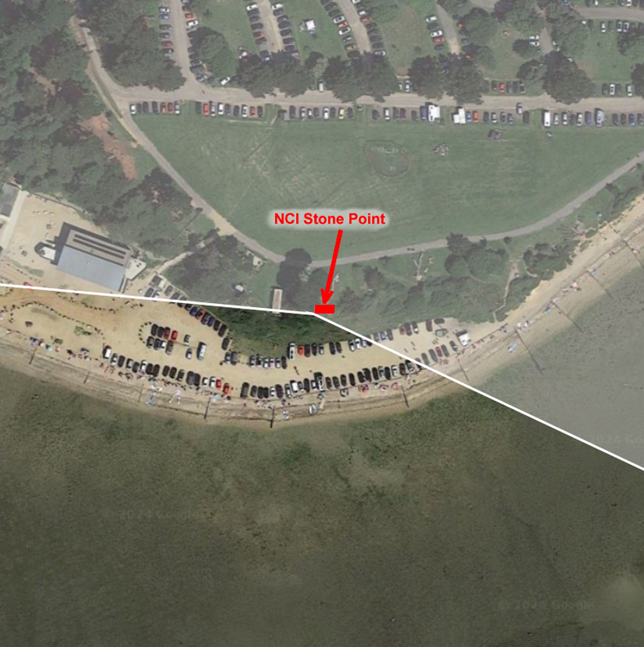 It corresponds to wind directions from about South-Southeast to West. This is shown by the non-shaded region on the aerial view.
For winds from NNE to ESE the BF estimates indicated by the Stone Point met station are two or three BF intervals less than those at Bramble. That suggests that a BF 7 “Near Gale” from the NE might be recorded by the anemometer as a BF 4 “Moderate Breeze”… that would be a big difference if you are out on the water!
Even a well sited anemometer at a coastal location will under-estimate the actual wind strength over the water when the wind is blowing from the land towards the sea. Any land surface, even a flat grassy field, will slow the air flow down more than the water surface does. That is because the waves on the water are free to move with the wind. In addition on land there are almost always obstructions to the wind caused by trees, hedges, buildings, etc. and their wakes extend far downwind.
 What these data emphasise is that we need to ensure that watchkeepers at NCI Stone Point take care when using the anemometer readings to estimate the wind over the water. If the wind is not blowing from the water towards the station, then the Beaufort Force estimate should be checked (and probably increased) by looking at other indicators – the wind at Bramble Met Post, the appearance of the water, the effect of the wind on sailing yachts, etc.
How well anemometer winds recorded at other NCI Stations represent the actual wind over the nearby water will vary greatly depending on the station location and the wind direction. An NCI station on a cliff top may occasionally record increased winds (as seen at the National Trust site at the Needles). In contrast, an NCI station on a sea front Promenade may be sheltered by nearby hotels and apartment blocks and often record much reduced wind strengths.
I ended by suggesting that “if you are deciding whether to venture out on the water, don’t simply rely on anemometer readings from coastal locations!”