
8th April: (d) Weather during the event
Other pages: [(a) Index Page] [(b) Water Levels] [(c) Photographs] [(d) Weather]

Fig.1a: Met Office analysis chart for 00UTC 9th April (01 BST).
The Met Office analysis (Fig.1a) for 01:00BST/9th shows a small depression with central pressure 992mb to the west of Southampton.
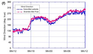
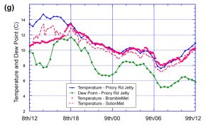
The graphs (Fig.1b-g) show the sequence of weather conditions from noon on 8th April 2024 until noon on the 9th. The data sources are a weather station at the end of a jetty at 84 Priory Road, the “SotonMet” website representing conditions at Dock Head, Bramble Met Post (‘BrambleMet”) and, for verification of the air pressure, NCI Stone Point.
[click on the thumbnails below to enlarge]
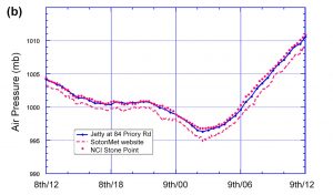
The minimum sea level pressure observed in St Denys (Fig.1b) was at 02:30BST with a value of 995.9mb which was in good agreement with that recorded at NCI Stone Point (995.8mb). The Bramble Met Post (not shown) shwed a similar variation but the minimum pressure (996.3) occurred at 03:20. The SotonMet website minimum value of 994.8mb was consistent with that site reading low by about 1mb, possibly it is not corrected to sea level. A pressure of 995mb would result in an inverse barometer effect of around 25cm surge. However the pressure at the time of maximum surge was about 998mb suggesting a surge of around 20cm.
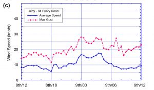
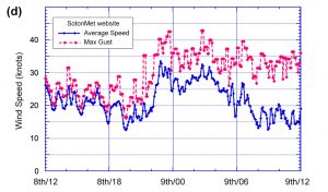
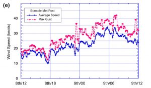
The wind speeds recorded at the jetty at no.84 Priory Road in the early hours of 9th April were about 15 to 17 knots average and 25 to 28 knots maximum gust (see Fig.1c). These wind speed reflect the sheltering effect of the city buildings. More representative of the winds over the water, SotonMet (from Dock Head – Fig.1d) recorded average speeds around 25 to 33 knots, and gust speeds between 30 to 43 knots. Curiously, Bramblemet winds were somewhat lower with average 25 to 30 knots, and gusts between 30 and 40 knots. These values fit my previous experience that gust speeds in St Denys are a good indication of average winds over the Solent.
The wind direction during the evening of the 8th (Fig.1f) was southwesterly backing to south-southwest for the period midnight to about 02:30/9th after which the wind veered to westerly by about 06:00/9th and continuing to veer after that time. The varying difference in observed wind speeds at SotonMet and BrambleMet as the wind became westerly and then more northwesterly probably reflect the fetch over land at SotonMet compared to the over water fetch at BrambleMet.
Up to 18:00 on the 8th the air temperatures (Fig1.g) show differences in daytime heating between the sites. However they are consistent after that time. The dew point depression indicates drier air in the evening of the 8th with a period of moister air during the early hours of the 9th possibly associated with the central area of the depression. There is a return to drier air after 06:00 on the 9th. It is difficult to associate these changes with the precise passage of the two bent-back occlusions shown on the weather chart.
[(a) Index Page] [(b) Water Levels] [(c) Photographs] [(d) Weather]