
11th March: WWII Hard at Lepe
 An ex-Oceanography colleague had told me that part of Nevil Shute’s novel “Requiem for a Wren” is set in the Exbury and Lepe area. Reading it I was intrigued by the references to “Lepe Hard” being used to load tank landing craft. It was described as being viewed from Lepe House which meant it was some distance from the “D-Day remains” in Lepe Country Park which are beyond Stansore Point and face Stanswood Bay.
On 11th March I was helping deliver a Chart Work course in the Lepe Country park Training Hut so afterwards I walked along the shore road to the point near the Millennium lighthouse where the road curves away from the shore and a ramp leads to the beach.
Although I had walked down the ramp before I had not noticed that it is constructed of the beach hardening mats, similar to those on the beach at the Stansore Point D-Day remains. Also that, underneath all the encroaching grass and scrub, it is quite a wide ramp. Furthermore it leads down to a wide concrete apron on the foreshore which extends westwards to a gate across a concrete road which ascends up through the grounds of Lepe House. This was obviously the “Lepe Hard” of Nevil Shute’s book.
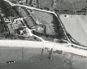
Afterwards I did some research and discovered that this was “Q Hard” as described by the D-Day Lepe Heritage Group, the New Forest Knowledge website, and the book “The Beaulieu River Goes to War” by Cyril Cunningham. The hard can be seen in an aerial photo from April 1946 (Historic England Photograph: raf_3g_tud_uk_163_vp2_5181).
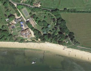
I have scaled and aligned a portion of the 1946 photo to allow comparison with a modern day aerial photo from Google Maps….
Here are the photos I took of the Hard remains. On the gate leading to Lepe House was a poster saying that the garden would be open on the 2nd April and i decided to visit then.
![[01] The Track Down From Lepe Road With The Millenium Lighthouse](https://seatern.uk/wp-content/uploads/2023/04/IMG_4559ps-300x200.jpeg)
![[02] Made Of WWII Beach Hardening Mats The Track Is Partly Overgrown](https://seatern.uk/wp-content/uploads/2023/04/IMG_4560ps-300x200.jpeg)
![[03] The Concreted Hard Area Is Partially Covered In Shingle And Sand](https://seatern.uk/wp-content/uploads/2023/04/IMG_4563ps-300x200.jpeg)
![[04] The Only Sign Of Any Buildings At The Hard](https://seatern.uk/wp-content/uploads/2023/04/IMG_4562ps-300x200.jpeg)
![[05] At The West End Of The Hard A Concrete Road Goes Up Towards Lepe House](https://seatern.uk/wp-content/uploads/2023/04/IMG_4563ps2-300x200.jpeg)
![[06] A Poster Advertising The Garden Being Open](https://seatern.uk/wp-content/uploads/2023/04/IMG_4564ps-300x200.jpeg)
![[07] The WWI Concrete Road Up To The House And Hence To Lepe Road](https://seatern.uk/wp-content/uploads/2023/04/IMG_4565ps-300x200.jpeg)
![[08] Looking East Along Q Hard (or "Lepe Hard").jpg](https://seatern.uk/wp-content/uploads/2023/04/IMG_4569ps-300x200.jpeg)
![[09] Lepe House From Q Hard](https://seatern.uk/wp-content/uploads/2023/04/IMG_4568ps-300x200.jpeg)